


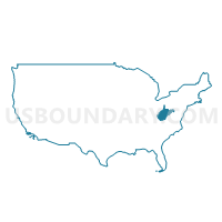
Randolph, Upshur, Barbour, Lewis, Hardy, Grant, Pendleton & Tucker Counties PUMA, West Virginia
About
Outline

Summary
| Unique Area Identifier | 194373 |
| Name | Randolph, Upshur, Barbour, Lewis, Hardy, Grant, Pendleton & Tucker Counties PUMA |
| State | West Virginia |
| Area (square miles) | 4,311.17 |
| Land Area (square miles) | 4,294.93 |
| Water Area (square miles) | 16.24 |
| % of Land Area | 99.62 |
| % of Water Area | 0.38 |
| Latitude of the Internal Point | 38.96217930 |
| Longtitude of the Internal Point | -79.63014620 |
Maps

Randolph, Upshur, Barbour, Lewis, Hardy, Grant, Pendleton & Tucker Counties PUMA in West Virginia
Download
Graphs
Select a template below for downloading or customizing gragh for Randolph, Upshur, Barbour, Lewis, Hardy, Grant, Pendleton & Tucker Counties PUMA, West Virginia


Neighbors
Neighoring Public Use Microdata Area (by Name) Neighboring Public Use Microdata Area on the Map
- Allegany & Garrett Counties--Cumberland City PUMA, MD
- Berkeley, Jefferson, Mineral, Hampshire & Morgan Counties PUMA, WV
- Central Shenandoah Planning District Commission (Northeast) PUMA, VA
- Central Shenandoah Planning District Commission (Southwest) PUMA, VA
- Greenbrier, Nicholas, Summers, Monroe & Pocahontas Counties PUMA, WV
- Harrison, Marion, Taylor & Doddridge Counties PUMA, WV
- Jackson, Wetzel, Roane, Braxton, Ritchie, Tyler, Gilmer & Calhoun Counties PUMA, WV
- Monongalia & Preston Counties--Morgantown City PUMA, WV
- Northern Shenandoah Valley Regional Commission (North) PUMA, VA
- Northern Shenandoah Valley Regional Commission (South) PUMA, VA
Top 10 Neighboring County (by Population) Neighboring County on the Map
- Frederick County, VA (78,305)
- Rockingham County, VA (76,314)
- Augusta County, VA (73,750)
- Harrison County, WV (69,099)
- Shenandoah County, VA (41,993)
- Preston County, WV (33,520)
- Garrett County, MD (30,097)
- Randolph County, WV (29,405)
- Mineral County, WV (28,212)
- Upshur County, WV (24,254)
Top 10 Neighboring County Subdivision (by Population) Neighboring County Subdivision on the Map
- Ashby district, Rockingham County, VA (21,326)
- Plains district, Rockingham County, VA (14,628)
- Leadsville district, Randolph County, WV (13,500)
- Back Creek district, Frederick County, VA (13,015)
- Southern district, Harrison County, WV (12,803)
- Central district, Rockingham County, VA (12,774)
- Southwest district, Harrison County, WV (10,423)
- District 1, Mineral County, WV (9,275)
- North River district, Augusta County, VA (9,227)
- Third district, Upshur County, WV (8,355)
Top 10 Neighboring Place (by Population) Neighboring Place on the Map
- Elkins city, WV (7,094)
- Buckhannon city, WV (5,639)
- Weston city, WV (4,110)
- Philippi city, WV (2,966)
- Moorefield town, WV (2,544)
- Petersburg city, WV (2,467)
- Belington town, WV (1,921)
- Parsons city, WV (1,485)
- Mill Creek town, WV (724)
- Franklin town, WV (721)
Top 10 Neighboring Unified School District (by Population) Neighboring Unified School District on the Map
- Frederick County Public Schools, VA (78,305)
- Rockingham County Public Schools, VA (76,314)
- Augusta County Public Schools, VA (73,750)
- Harrison County School District, WV (69,099)
- Shenandoah County Public Schools, VA (41,993)
- Preston County School District, WV (33,520)
- Garrett County Public Schools, MD (30,097)
- Randolph County School District, WV (29,405)
- Mineral County School District, WV (28,212)
- Upshur County School District, WV (24,254)
Top 10 Neighboring State Legislative District Lower Chamber (by Population) Neighboring State Legislative District Lower Chamber on the Map
- State House District 29, VA (88,049)
- State House District 26, VA (82,704)
- State House District 15, VA (78,102)
- State House District 20, VA (76,800)
- State House District 41, WV (71,101)
- State Legislative Subdistrict 1A, MD (39,216)
- State House District 37, WV (38,124)
- State House District 51, WV (20,765)
- State House District 40, WV (20,319)
- State House District 42, WV (19,954)
Top 10 Neighboring State Legislative District Upper Chamber (by Population) Neighboring State Legislative District Upper Chamber on the Map
- State Senate District 27, VA (227,068)
- State Senate District 26, VA (201,456)
- State Senate District 24, VA (200,978)
- State Senate District 15, WV (122,121)
- State Senate District 14, WV (121,969)
- State Senate District 1, MD (118,930)
- State Senate District 11, WV (108,768)
- State Senate District 12, WV (108,687)
- State Senate District 2, WV (101,327)
Top 10 Neighboring 111th Congressional District (by Population) Neighboring 111th Congressional District on the Map
- Congressional District 10, VA (869,437)
- Congressional District 6, MD (738,943)
- Congressional District 6, VA (704,056)
- Congressional District 2, WV (648,186)
- Congressional District 1, WV (615,991)
- Congressional District 3, WV (588,817)
Top 10 Neighboring Census Tract (by Population) Neighboring Census Tract on the Map
- Census Tract 504, Frederick County, VA (6,748)
- Census Tract 9677, Gilmer County, WV (6,390)
- Census Tract 9664, Randolph County, WV (6,086)
- Census Tract 7, Garrett County, MD (5,726)
- Census Tract 9686, Hampshire County, WV (5,469)
- Census Tract 9679, Braxton County, WV (5,303)
- Census Tract 9657, Barbour County, WV (5,276)
- Census Tract 9702, Hardy County, WV (5,110)
- Census Tract 9648, Taylor County, WV (5,079)
- Census Tract 112, Rockingham County, VA (4,929)
Top 10 Neighboring 5-Digit ZIP Code Tabulation Area (by Population) Neighboring 5-Digit ZIP Code Tabulation Area on the Map
- 26201, WV (19,701)
- 26241, WV (14,591)
- 26330, WV (14,377)
- 21550, MD (14,194)
- 26726, WV (13,306)
- 26354, WV (11,135)
- 26452, WV (9,676)
- 26416, WV (7,529)
- 26836, WV (6,578)
- 26757, WV (6,464)